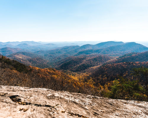
The USA is a hiker’s dream country for its diverse landscape. Each state has a seemingly endless variety of hiking spots ranging from snow capped peaks, jagged cliffs, towering volcanoes and old-growth forests. There is over 193 000 miles of federal hiking trails on federal land. But which trails are the best hiking trails in the USA? Here are five hiking spots that offer something unique to both satisfy your senses and fuel your sense of adventure.

Best hiking trails in the US
With thousands of miles of trails in the United States, there is no shortage of places to hike. These 5 trails are some of the country’s most popular. Even if you don’t have 3-4 months to hike one of these epic trails you can still enjoy their beauty with some of the shorter footpaths and day hikes. Read on to learn about 5 of the top hiking spots in the USA.

South Kaibab Trail, Grand Canyon National Park, Arizona
South Kaibab Trail hiking spot is one of the best spots to experience the Grand Canyon. This trail inclines a series of steep, wide-open switchbacks, allowing you to grip the magnitude of the canyon as you gaze into its depths. You can stare at the views right from the canyon rim, but they continue to progress and enlarge with every step down the trail.
This trail is the straightest route to the Colorado River where you follow the steep ridge line into the canyon. You have to start your hike at Yaki Point on the canyon rim. There is no water present along the South Kaibab Trail and you’ll have to carry at least four liters of water along with you for hiking during the hot summer season.
After starting your hike as you continue your descent, you weave through Kaibab Limestone and a new layer of rock Coconino Sandstone. There are two chief turnaround points for day hikers: Cedar Ridge and Skeleton Point. Cedar Ridge is a 3-mile round trip hike and Skeleton Point is 6 miles round trip hike in total. From the Skeleton Point, you can have your first panoramic view of the Colorado River, almost 3000 feet below you.
This hiking spot is available all year-round but requires special considerations in certain seasons. Spring season is the ideal time to hike the South Kaibab Trail, as summer temperatures have dropped but winter seasons have not yet set in. From May month to September, avoid hiking at mid-day between 10 AM and 3 PM as heat precautions should be taken.

Vesper Peak, North Cascades, Washington
Vesper Peak is a very nice hiking spot located in the heart of the Cascade Range, between a sea of rocky ridge-lines and deep blue alpine lakes. The hike begins in a dense, mossy forest and takes you over a stream crossing. From there, it rapidly opens up into a gorgeous basin with towering peaks on both sides. The elevation of this peak is about 6218 feet with panoramic views at the summit.
Along with that, you can get an unforgettable view of the bright green of the forests, the azure of Copper Lake in the valley, the icy-blue of Lake Elan, and the iron red of Big Four Mountain.
As you move forward, you can head towards the Headlee Pass. From Headlee Pass, you can get the beautiful and mesmerizing view of the Vesper Peak towering high in the distance. This peak is not ideal for the novice hiker. There is high avalanche danger during the melting months in the Upper Basin.
An Interagency Pass or Northwest Forest Pass is essential to park at the trailhead. You need to ensure to sign the trail register before setting out on your hike. This trail is generally snow-free from mid-July through September.

Ice Age Trail
The Ice Age Trail is one of the most famous long-distance hiking trails in the USA and is one of the country’s National Scenic Trails. The main route of this 1200 mile hiking trail starts from Interstate state park on the Wisconsin-Minnesota border to Potawatomi state park on Lake Michigan. This trail follows the following mountain ranges running from north to south: Appalachian, Continental Divide, and Pacific Crest and is entirely within the state of Wisconsin.
More than 12,000 years ago, an immense flow of glacial ice sculpted a landscape of remarkable beauty across Wisconsin. As the glacier retreated, it left behind a variety of unique landscape features. This hiking trail follows a zig-zagging line of rock piles popularly known as moraines and several other ice age relics such as long ridge lines known as eskers, large boulders as well as small basins left by melting ice chunks commonly known as kettle ponds.
The trail is open for day hikes, overnight stays and multi-day adventures.

Continental Divide Trail
The main route of this 3100 mile hiking trail starts at the Canadian border in Glacier National Park, Montana, and ends at the Mexican border west of El Paso. You’ll hike through Idaho, Wyoming, Colorado, and New Mexico. Considered one of the greatest long-distance trails in the world, it is the highest, most challenging, and most remote of our National Scenic Trails
The Continental Divide Trail passes through several rough mountain regions of Colorado such as the San Juan Mountains in the southern part of the state and the Sawatch Range in the central region. There are numerous points of interest along the Colorado Continental Divide Trail which includes Collegiate Peaks, Grays Peak, Mount Elbert, and Mount Massive, Rabbit Ears Pass, Rocky Mountain National Park, Wolf Creek Pass, North Park, Middle Park, and South Park.
For the long-distance hiking community, the CDT is one-third of the “Triple Crown,” and annually, while the number is growing, approximately 150 ambitious travelers attempt to complete an end-to-end trek.
The ideal time for hiking in Colorado Continental Divide Trail is from late April to September.
The Appalachian Trail
The Appalachian Trail is the longest hiking only foot path in the world. This popular hiking trail is located in the eastern part of the United States. The main route of this 2,190 mile hiking trail starts from Springer Mountain in Georgia to Mount Katahdin in Maine. Its highest point is 2025 meter Clingman’s Dome in the Great Smoky Mountains in Tennessee.
Hikes on the A.T. can range from easy, beginner-friendly, to extremely difficult. Elevation gain (the amount of climbing) and the smoothness of the footpath (or lack of it due to rocks and roots) are the primary elements of difficulty. Most states have some short, easy sections (Georgia, New Hampshire, and Maine have the fewest). Almost every state has sections that some (or all) hikers would consider difficult. Know what you’ll be getting into so you pick the hike that’s right for you and adjust your mileage (or your location) accordingly.
Mount Madison is considered the difficult part of the Appalachian Trail. The ideal time for hiking in Appalachian Trail is from late May to mid-June.
FAQ’s about the best hiking trails in US
The answer to this will depend on who you ask and their personal experience but the following hikes are considered some of the most difficult:
Mount Olonoma – Hawaii
Devil’s Path, Catskills – New York
The Mahoosuc Mile, Appalachian Trail – Maine
Lone Eagle Peak, Indian Peaks Wilderness – Colorado
Upper Slickrock Creek Trail, Joyce Kilmer-Slickrock Wilderness – North Carolina
Borah Peak, Lost River Range – Idaho
The Maze, Canyonlands – Utah
The America Discovery Trail covering 6800 miles and crosses the USA from Delaware to California. It is the only coast to coast recreational trail in the US.
There are over 88,000 miles of hiking trails on federal lands in the United States of America.
The Appalachian Trail takes five to seven months to complete its 2,190 miles, while the Pacific Crest Trail takes four to six months to complete 2,650 miles of trail. Most people who’ve hiked both trails will crown the AT as the more difficult trail.
What do you think the best hiking trail in the US is? Let me know in the comments!
Leave a Reply